

FINANCIAL AND MARKET MODELLING


NEW GENERATION CONSULTING
CAPABILITIES
BUSINESS STRATEGY
BENEFITS REALISATION
BUSINESS PROCESS
MANAGEMENT &
IMPROVEMENT
BUSINESS TRANSFORMATION
AND ARCHITECTURE
RELATIONSHIP MANAGEMENT
& NEGOTIATION
PROJECT MANAGEMENT
FINANCIAL & MARKET
MODELLING
NEW GENERATION
CONSULTING
12 Alexander Street,
Box Hill,
Victoria 3128
T: +613 98987550
M: +61 409 431 452
E: david@ngconsulting.com.au
E: steven@ngconsulting.com.au
W: www.ngconsulting.com.au
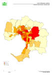
New Generation Consulting has developed several Geo-Spatial Information Systems (GIS) for a raft of clients with differing needs. These GIS models have been used an aide or adjunct to the specific assignment. NGC
 are able to design a GIS model that meets the Client’s specific needs it can be a simple 2-D model or a very
 complex multi layered and multi dimensional.
 •
Maximise Asset Utilisation
 •
Marketing (Research, Strategic & Targeted)
•
Strategic Planning
•
Integration of Projects
•
Land Use Management/Utilisation
•
Marketing (Research, Strategic & Targeted)
•
Strategic Planning
•
Integration of Projects
•
Land Use Management/Utilisation •
Supply and Demand Forecasting
As long as there is sufficient historical data robust accurate forecasting can be derived from the GIS tool.
 reference layer (specified by the client)
•
Develop Slice and Dice analyses of the data.
•
Develop on-line or hard copy “Standard” and “Ad-Hoc” reports (in pictorial, graphical, tabular and word
 formats)
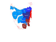
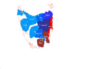
 State-wide Long-Term supply and demand forecasting regime developed for a Distribution company in order to
 determine the following:
 •
Growth in Demand (By Region and by Customer Segment)
 •
Supply Availability (By Region and by Customer Segment)
 •
Age of Asset (By Region and by Asset Class)
•
Replacement, Retirement or Network Augmentation (By Region and by Asset Class)
•
Age of Asset (By Region and by Asset Class)
•
Replacement, Retirement or Network Augmentation (By Region and by Asset Class) •
Utilisation (By Region and by Customer Segment and by Asset Class)
 •
Potential for Network Load switching between Regions and Intra-Regional assets
 •
Ability to identify visually areas of concern
 with differing needs. These GIS models have been used an aide or adjunct to the specific assignment. NGC
 are able to design a GIS model that meets the Client’s specific needs it can be a simple 2-D model or a very
 complex multi layered and multi dimensional.
Examples of GIS modelling:
• Asset Management •
Maximise Asset Utilisation
 •
Marketing (Research, Strategic & Targeted)
•
Strategic Planning
•
Integration of Projects
•
Land Use Management/Utilisation
•
Marketing (Research, Strategic & Targeted)
•
Strategic Planning
•
Integration of Projects
•
Land Use Management/Utilisation •
Supply and Demand Forecasting
As long as there is sufficient historical data robust accurate forecasting can be derived from the GIS tool.
Methodology:
• “Business” and modelling rules developed • Develop specific model parameters including base case and scenarios • Include industry standard and client specific formulae in the model • As the reference layer develop and install in the model a detailed map of the area in question • Add Client and Public Domain historical data to the model to form the additional layers over laying the reference layer (specified by the client)
•
Develop Slice and Dice analyses of the data.
•
Develop on-line or hard copy “Standard” and “Ad-Hoc” reports (in pictorial, graphical, tabular and word
 formats)
Case Study:
Utilities Asset Management & Utilisation System State-wide Long-Term supply and demand forecasting regime developed for a Distribution company in order to
 determine the following:
 •
Growth in Demand (By Region and by Customer Segment)
 •
Supply Availability (By Region and by Customer Segment)
 •
Age of Asset (By Region and by Asset Class)
•
Replacement, Retirement or Network Augmentation (By Region and by Asset Class)
•
Age of Asset (By Region and by Asset Class)
•
Replacement, Retirement or Network Augmentation (By Region and by Asset Class) •
Utilisation (By Region and by Customer Segment and by Asset Class)
 •
Potential for Network Load switching between Regions and Intra-Regional assets
 •
Ability to identify visually areas of concern
Copyright New Generation Consulting Pty. Ltd. Updated October 2014


New Generation Consulting has developed several Geo-Spatial Information Systems (GIS)
for a raft of clients with differing needs. These GIS models have been used an aide or adjunct to
the specific assignment. NGC are able to design a GIS model that meets the Client’s specific
needs it can be a simple 2-D model or a very complex multi layered and multi dimensional.
Examples of GIS modelling:
• Asset Management • Maximise Asset Utilisation • Marketing (Research, Strategic & Targeted) • Strategic Planning • Integration of Projects • Land Use Management/Utilisation • Supply and Demand Forecasting As long as there is sufficient historical data robust accurate forecasting can be derived from the GIS tool.Methodology:
• “Business” and modelling rules developed • Develop specific model parameters including base case and scenarios • Include industry standard and client specific formulae in the model • As the reference layer develop and install in the model a detailed map of the area in question • Add Client and Public Domain historical data to the model to form the additional layers over laying the reference layer (specified by the client) • Develop Slice and Dice analyses of the data. • Develop on-line or hard copy “Standard” and “Ad-Hoc” reports (in pictorial, graphical, tabular and word formats)Case Study:
Utilities Asset Management & Utilisation System State-wide Long-Term supply and demand forecasting regime developed for a Distribution company in order to determine the following: • Growth in Demand (By Region and by Customer Segment) • Supply Availability (By Region and by Customer Segment) • Age of Asset (By Region and by Asset Class) • Replacement, Retirement or Network Augmentation (By Region and by Asset Class) • Utilisation (By Region and by Customer Segment and by Asset Class) • Potential for Network Load switching between Regions and Intra-Regional assets • Ability to identify visually areas of concern


NEW GENERATION CONSULTING
FINANCIAL AND MARKET MODELLING


